Posts tagged London
London Bridges Half Marathon

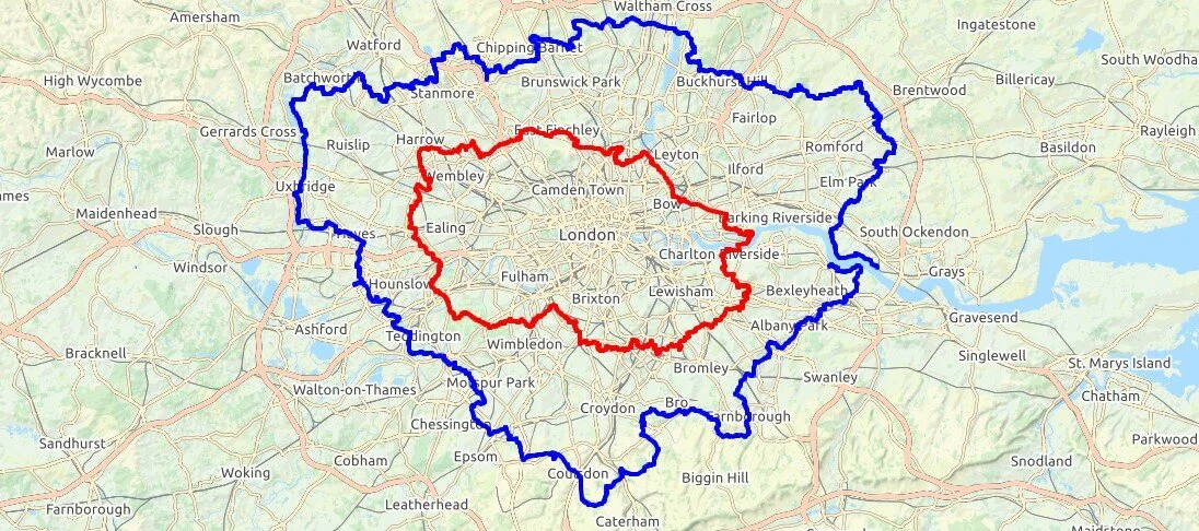
For a few years I imagined a half marathon that follows the Thames Path in London crossing every bridge along the way. On a chilly day in November, with only minor route planning on Google Maps, I gave it a go.

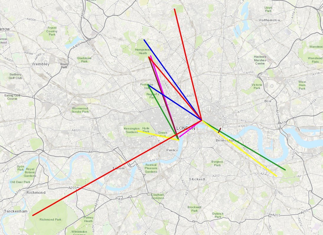
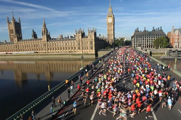
The route starts at Westminster Bridge, heading east towards Tower Bridge. The rules are that every accessible bridge must be crossed and each side of the river covered. This means a zig-zagging route up to Tower Bridge, then the opposite zig-zag back to Westminster and onwards to Chelsea Bridge. This marks the final turn back eastwards, finishing at County Hall on the South side of Westminster Bridge.

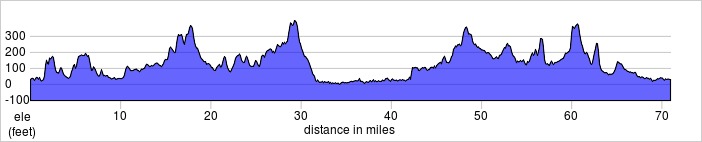
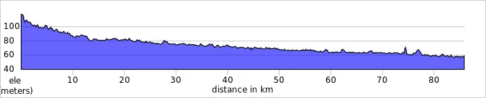
My Garmin read 14.1 miles at the end, 1 mile over a true half. Staying tighter to the river would have carved off most of that extra mile. I made this first attempt on a busy Saturday afternoon, and the crowds around Tower Hill and County Hall meant that a diversion was needed at times. My run took nearly 3 hours, mostly due to lack of carbs the day before and a very crowded route that became a slow walk in some parts. An early-morning crowdless route would be do-able in under 2hrs.

Its a great route for views of London and never boring. Its unlikely to be practical to be run as a large organised event due to the many road crossings and narrow alleys, but it works well for small groups.

Here's the details... (N) and (S) indicate North or South direction of travel across the bridge.

Map - London Bridges Half Marathon 1.png

Section 1

  • Start at Westminster Bridge North side by the Houses of Parliament

  • Head east along the Embankment towards Tower Bridge

  • Cross Hungerford Footbridge (S), head east

  • Cross Waterloo Bridge (N), head east

  • Cross Blackfriars Bridge (S), head east

  • Cross the Millennium Footbridge (N), head east

  • Cross Southwark Bridge (S), head east

  • Cross London Bridge (N), head east

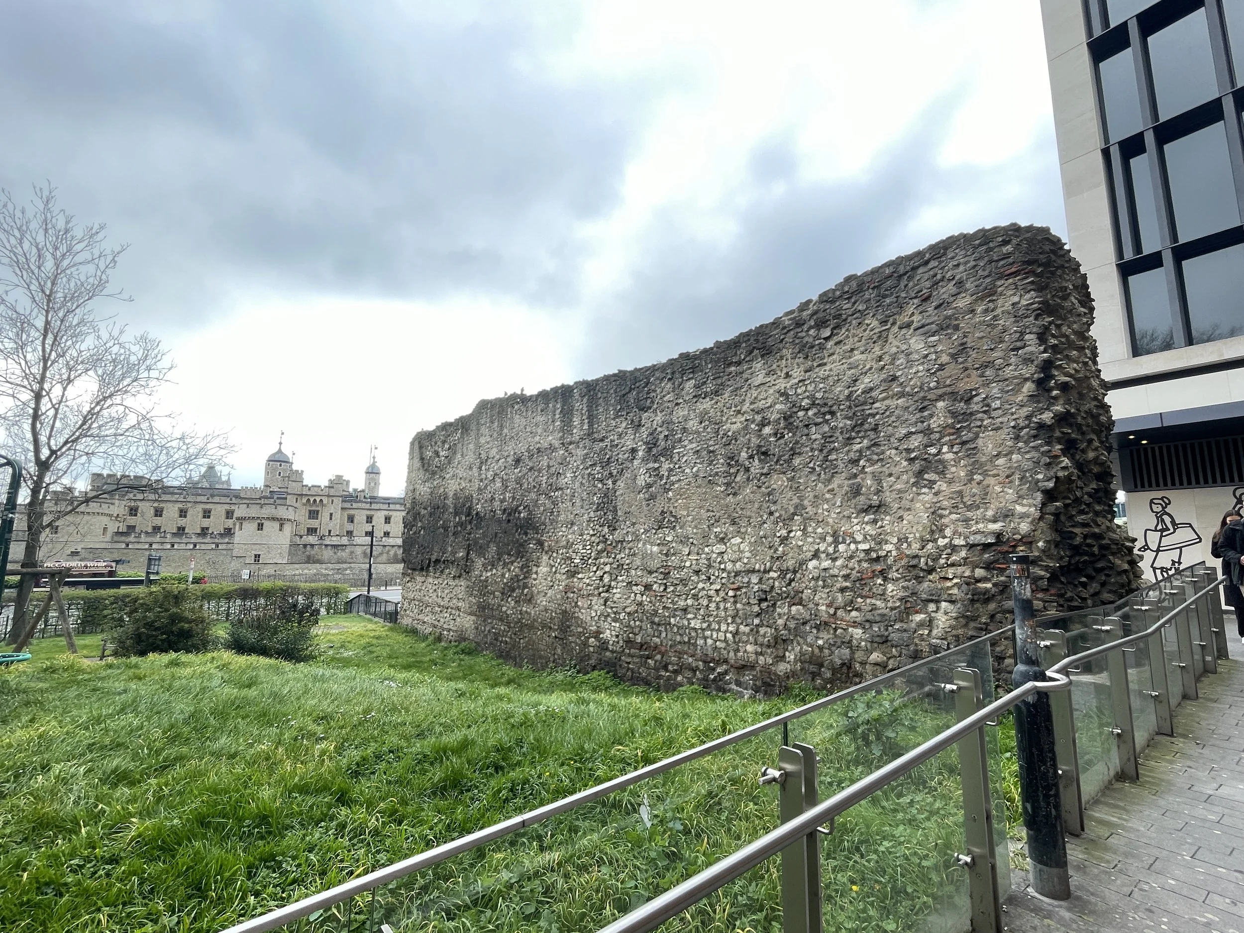
  • Cross Tower Bridge (S), now start heading back towards Westminster

Section 2

elevation_profile - London Bridges Half Marathon 1.jpg
  • Cross London Bridge (N), head west

  • Cross Southwark Bridge (S), head west

  • Cross the Millennium Footbridge (N), head west

  • Cross Blackfriars Bridge (S), head west

  • Cross Waterloo Bridge (N), head west

  • Cross Hungerford Footbridge (S), head west

  • Cross Westminster Bridge (N), head west

  • Cross Lambeth Bridge (S), head west

  • Cross Vauxhall Bridge (N), head west

  • Cross Chelsea Bridge (S), now start heading east back towards Westminster

Section 3

  • Cross Vauxhall Bridge (N), head east

  • Cross Lambeth Bridge (S), head east

  • Finish at Westminster Bridge, south side by County Hall


Cycling London's Capital Ring
View to the city on the northern section

View to the city on the northern section


Start & Finish: Old Deer Park Car Park, Park Lane, Richmond, TW9 2RA
Distance: 127 km / 79 miles
Elevation Change: + / - 1,017m
GPX File: get via Buy Me a Coffee
Other Routes Touched (Walk): Thames Path, Wandle Trail, Green Chain Walk, King John’s Walk, Explore Charlton Trail, Jubilee Greenway, The Greenway, Lea Canal Towpath, Lea Valley Walk, New River Path, Grand Union Canal Towpath
Other Routes Touched (Cycle): NCN 1, 13, 20, 21, 4 / CS 1, 2, 3
Guidebook: The Capital Ring by Colin Saunders. Arum Press.
Maps:
- OS Explorer Map (161) London South, Westminster, Greenwich, Croydon, Esher & Twickenham
- OS Explorer Map (173) London North, The City, West End, Enfield, Ealing, Harrow & Watford


The Capital Ring is a 78 mile walking route circling inner and central London. It was established in 2005 as a continuous signposted route that takes in many of London’s parks and green spaces. Whilst there are many books and articles detailing how to walk it, there’s very little in the way of advice for cyclists. That’s probably intentional as some parts, particularly Richmond Park and Wimbledon Common, specifically prohibit cycling along the route.

My first attempt at cycling the Capital Ring was in 2013, 6 months after a successful 2-day adventure on its big sister, the 150 mile London Loop. Having found the Loop relatively straightforward I considered the Ring to be easy. My first attempt with 2 friends failed spectacularly with a combination of my ineffective navigation, Brian’s broken bike and Ray’s broken body. A broken chain en-route to the start and some confusion over the meet-up point meant an 11 am start, far too late for a 70+ miler on an autumn day. We decided to see how far we could get and less than 20 miles in we realised it wasn’t going to happen. We ended up with a smaller 45 mile trip. A nice day but we hadn’t conquered the Capital Ring.

I’d learnt my navigation lesson by the 2nd attempt 1 year later. Previously I’d been relying only on Colin Saunders’ excellent guide to the route. It's appropriately detailed and, whilst great for walkers, it's not something that you can read whilst cycling at speed. Although the route is well signposted it'seasy to miss the signs every now and then. The solution for attempt 2 was a handlebar mounted iPhone case and a cycling app with a GPX file of the route. This was the single most important reason that we were able to complete the route in a day.

The route itself is a well thought-out mix of some well-known and unfamiliar parts of London. Although the official start is the Woolwich tunnel on the eastern side, you can pick it up wherever you want. We started on the far west at Richmond Bridge going anti-clockwise. This gave us some amazing early-morning views across Richmond Park and some great photo opportunities with the deer. The official Capital Ring route through the park prohibits cycling so its important to take a detour here to avoid annoying the early morning walkers and the potential £50 fine for cycling on the wrong paths.

The rest of the south side is fairly scenic taking in Wimbledon Common, Streatham and on to Eltham. The route crosses the river at the Woolwich Foot Tunnel before the less than scenic parts around London City Airport and Barking. The route gets interesting again when it joins a long stretch of converted railway called the Greenway taking you to the Queen Elizabeth Olympic Park.

The North London section is mostly a nice combination of canals and parks with some busy sections around the A1/A406 road links near Brent Cross. This section reaches its literal peak at Harrow On The Hill which, based on our chosen start point, came just as the sun went down and tiredness set in. From Harrow it's down-hill all the way back to Richmond Bridge. The official route takes advantage of canal and stream towpaths although we took an alternative road-based route trying to avoid falling into the Grand Union in the dark.

Our experience proved that cycling the Capital Ring is both practical and rewarding. There’s no detailed guide to cycling the Ring yet, so I recommend some careful planning and being prepared for some spontaneous detours. I would say that ~90% of the route is cycle friendly with easy alternatives for the rest. A good GPS device will help you get back on track when you get lost or need to make a detour to avoid a muddy hill. For enjoyment go for 2 days and take a slow pace. This will give you time to read the guide book as you go and learn about the interesting places along the way. The 1 day version we did becomes a very different experience altogether as it's more of a physical and navigational challenge. Either way it's an incredibly rewarding route and a unique way to see the Capital.

route-26640052-map-full.png
Capital Ring Elevation Profile

Capital Ring Elevation Profile


The Capital Ring and The London Loop

London Loop in Blue, Capital Ring in Red. Base map from OpenStreetMap

London Loop in Blue, Capital Ring in Red. Base map from OpenStreetMap


More London posts


Royal Parks Half Marathon

When: October 12th 2014
Where: London, UK
Course: Start and end in Hyde Park via Green Park, St James', Westminster Bridge and The Embankment
Other routes touched (walk): Thames Path, Jubilee Walkway, Jubilee Greenway, Diana Princess of Wales Memorial Walk
Other routes touched (cycle): None
Finish time:
 1:47

The London Royal Parks may have been my 17th Half Marathon, but it was by far my most important. This year I was running for Cancer Research UK as the first event in Growlerthon2015, my year of fundraising. I’d been trying to get into this race for years but always missed out via the public ballot. Running for a charity is great way to guarantee a place, and it comes with the responsibility of raising enough money for them.

The race is hugely popular as goes through some great London scenery. There’s 3 of the Royal Parks: Hyde, Green and St James, plus Buckingham Palace, Parliament Square, Westminster Bridge, the Embankment and Admiralty Arch.

October 12th was a beautiful Autumn day with excellent running conditions. I’m not fond of running in the heat and that day was nicely chilly. The flat course, the buzz of the crowds and Timi and her parents there to support all contributed to a great race and a Personal Best of 1:47.

A very large glass of wine helped to finish the day and was the decider to return in 2015 for the 42 mile Royal Parks Ultra.

 
Grand Union Half Marathon

When: November 10th 2013
Where: Cowley (Middlesex) to Watford (Hertfordshire), UK
Course: Point to point: Grand Union towpath from Cowley recreational ground, ending in Cassiobury Park
Other routes touched (walk): Grand Union Canal, London Loop, Colne Valley Trail, Hillingdon Trail
Other routes touched (cycle): NCN Route 6, 61
Finish time: 2:03

 
Betsom's Hill: Kent County Top

Significance: Highest peak in Kent (Historic CT)
Member of: N/A
Parent Peak: Botley Hill. NHN = Botley Hill
Elevation:
 251m
Date “climbed”: 3rd November 2013
Coordinates:  51°17′18″N 0°03′26″E
Route Start / End: Parking / Bus stop on A233
Route Distance: 0.2 km (0.1 miles)
Route Elevation Change: +/- 2m
Subsidiary tops on route: None
GPX File: get via Buy Me a Coffee
Other routes touched: None
Map: OS Explorer Map (147) Sevenoaks and Tonbridge
Guidebook: The UK's County Tops (Jonny Muir), Walking the County High Points of England (David Bathurst)
Links: Wikipedia (Kent), Wikipedia (Betsom’s Hill), Peakbagger, Hillbagging


I bagged Betsom’s Hill, the high point of the Historic County of Kent, in 2013 as a part of series of quick high-point drive-bys. It’s just over the border with Greater London so it can bagged within a short walk with Westerham Heights, the high point of Greater London. Nothing to see at either high point so do it on the way to much more interesting destinations along the North Downs Ridge.


Red = Betsom’s Hill. Green = Westerham Heights. Actual summits not accessible

Red = Betsom’s Hill. Green = Westerham Heights.

A peak so boring we only took 1 photo

elevation_profile.jpg

OTHER HIGH POINT IN Kent

Greater London Borough High Points formerly within Kent


Cycling The London Loop
Concrete barges at Rainham

Concrete barges at Rainham


The London Loop is a ~130-mile circular walking route of outer London. Although intended for walkers only, much of it is cyclable with just a few diversions from the main path. I completed it in a 2-day micro-adventure back in 2013. Please note that both the London Loop and Capital Ring were designed for walking. Much of both routes can be cycled as there’s many sections on cycle routes and roads. Some sections are on footpaths that should not be cycled so be prepared to find alternative routes around these.


Day 1: Southern Section: Harefield to Dartford

Start: The Coy Carp, Copperhill Lane, Harefield, Uxbridge UB9 6HZ
Finish: Grotty hotel near the Dartford Crossing, Kent
Distance:
110 km (68 miles)
Elevation Change: + 1.046m / - 1,082m. Net -36m
GPX File: get via Buy Me a Coffee
Other Routes Touched (Walk): Colne Valley Trail, Hillingdon Trail, Grand Union Canal Towpath, Celandine Route, Shakespeare’s Way, Beeches Way, Thames Path, Thames Down Link, Hogsmill Valley Walk, Town and Down Circular Walk, Sutton Countryside Walk, Vanguard Way, Greenwich Meridian Trail, Cray Riverway, Darent Valley Path
Other Routes Touched (Cycle): NCN 1, 125, 20, 21, 232, 4, 6, 61
Guidebook: The London Loop: Recreational Path Guide by Colin Saunders
Maps:
-
OS Explorer Map (172) Chiltern Hills East
- OS Explorer Map (160) Windsor, Weybridge & Bracknell
-
OS Explorer Map (161) London South, Westminster, Greenwich, Croydon, Esher & Twickenham
- OS Explorer Map (162) Greenwich and Gravesend 


Day 2: Northern Section: Dartford to Harefield

Start: Grotty hotel near the Dartford Crossing, Kent
Finish: The Coy Carp, Copperhill Lane, Harefield, Uxbridge, UB9 6HZ
Distance: 92 km (57 miles)
Elevation Change: + 967m / - 962m. Net +5m
GPX File: get via Buy Me a Coffee
Other Routes Touched (Walk): Havering Green Ways, Greenwich Meridian Trail, Lea Valley Walk, New River Path, Pymmes Brook Trail, Colne Valley Trail, Hillingdon Trail, Grand Union Canal Towpath
Other Routes Touched (Cycle): NCN 1, 13, 136, 3, 6, 61
Guidebook: The London Loop: Recreational Path Guide by Colin Saunders
Maps:
-
OS Explorer Map (173) London North, The City, West End, Enfield, Ealing, Harrow & Watford
- OS Explorer Map (172) Chiltern Hills East

You can't cycle over the Dartford Bridge or under the tunnel but there is a free service that drives you and your bikes through. There's a free phone at the entrance to the tunnel on either side.


The London Loop and Capital Ring

London Loop in Blue, Capital Ring in Red. Base map from OpenStreetMap

London Loop in Blue, Capital Ring in Red. Base map from OpenStreetMap


More London posts


London Marathon

When: April 13th 2008
Where: London UK
Course: All-road from Blackheath, Greenwich to The Mall via Docklands.
Start: Greenwich Park, London, SE10 8QY
Finish: The Mall, London, SW1A 1AA
Distance: 42.2 km (26.2 miles)
Elevation change: + 156 / - 194m. net -38m
Other Routes Touched (walk): Greenwich Meridian Trail, Green Chain Walk, Explore Charlton Trail, Capital Ring, Jubilee Greenway, Thames Path, Lea Valley Walk, Jubilee Walkway
Other Routes Touched (cycle): NCN 1, 13, 4, 425, / CS 3
Finish time: 4:27
Links: London Marathon, Blackheath, The Mall


Cycling The Thames Path

Windsor


The most important thing to say about cycling the Thames Path is “don’t cycle the Thames Path”. This was one of my first long distance cycle rides and, back in 1997, I didn’t put a lot of thought into it. Nowadays I put a lot of planning into trips to make sure that I use cycle-friendly paths. These were the pre-internet, pre-GPX days. Back then we just got a lift to the source and started cycling. If I was to do the Thames Path now I definitely wouldn’t cycle any of the first section to Oxford and I’d be choosy about parts of the middle section too.

Don’t just take my work for it though: from visitthames.co.uk: “Most of the Thames Path is a public footpath on which cyclists have no legal right to ride unless they have permission from the landowners - cycling without permission is a trespass offence against landowners. If you choose to cycle by the river, please be aware it is a potentially dangerous activity”.

The Thames Path is a magnificent National Trail and I highly recommend giving it a go. The easiest advice is to Walk to Maidenhead then cycle the rest. The reality is probably more nuanced though and I’m sure I’ll return to update the routes one day. In the meantime, here’s the sections as I did them in ‘97. Please use the comment box below if you have any more recent advice on cycling on the Thames path.


Part 1: Source To Oxford

Start: Thames Head Inn, Tetbury Rd, Cirencester GL7 6NZ (alternative = Kemble Railway Station)
Finish:
Oxford YHA, 2A Botley Rd, Oxford OX2 0AB
Distance: 86 km (53 miles)
Elevation change: +96m / - 254 m / Net -158m
GPX File: get via Buy Me a Coffee
Other Routes Touched (Walk): Thames Path, Wysis Way, Oxford Green Belt Way, Shakespeare’s Way
Other Routes Touched (Cycle): NCN 45
OS Map(s):
- OS Explorer 168 Stroud, Tetbury & Malmesbury
- OS Explorer 169 Cirencester & Swindon
- OS Explorer 170 Abingdon, Wantage & Vale of White Horse
- OS Explorer 180 Oxford, Witney & Woodstock 

elevation_profile - Thames Path 1.jpg

Part 2: Oxford To Hurley Lock

Start: Oxford YHA, 2A Botley Rd, Oxford OX2 0AB
Finish:
Hurley Lock, Mill Ln, Hurley, Maidenhead SL6 5ND
Distance: 57 miles / 91 km
Elevation change: +312m / - 339 m / Net -27m
GPX File: get via Buy Me a Coffee
Other Routes Touched (Walk): Thames Path, Shakespeare’s Way, Oxford Green Belt Way, European Walk E2: UK South East England, The Ridgeway, The Chiltern Way Berkshire Loop
Other Routes Touched (Cycle): NCN 4, 5, Chilterns Cycleway
OS Map(s):
- OS Explorer 180 Oxford, Witney & Woodstock
- OS Explorer 170 Abingdon, Wantage & Vale of White Horse 
- OS Explorer Map 171 Chiltern Hills West, Henley-on-Thames and Wallingford
- OS Explorer Map (172) Chiltern Hills East

elevation_profile - Thames Path 2.jpg

Part 3: Hurley Lock to Thames Barrier

Start: Hurley Lock, Mill Ln, Hurley, Maidenhead SL6 5ND
Finish:
Thames Barrier, Eastmoor St, Greenwich Peninsula, London SE7 8LX
Distance: 72 miles / 116 km
Elevation change: +435m / - 463 m / Net -28m
GPX File: get via Buy Me a Coffee
Other Routes Touched (Walk): Thames Path, Shakespeare’s Way, The Chiltern Way Berkshire Loop, Maidenhead Boundary Walk, London Loop, Capital Ring, Jubilee Walkway, Jubilee Greenway
Other Routes Touched (Cycle): NCN 1, 4, 61
OS Map(s):
- OS Explorer Map (172) Chiltern Hills East
- OS Explorer Map (160) Windsor, Weybridge & Bracknell
- OS Explorer Map (161) London South, Westminster, Greenwich, Croydon, Esher & Twickenham
- OS Explorer Map (173) London North, The City, West End, Enfield, Ealing, Harrow & Watford

map - Thames Path 3.JPG

The complete route


Related Blog Posts: